


PAGE OVERVIEW
After logging in, you will be redirected to the platform main page. This page allows to access most common tracking features and settings, monitor object position on map ant get detailed information such as speed, address, coordinates, history and more.
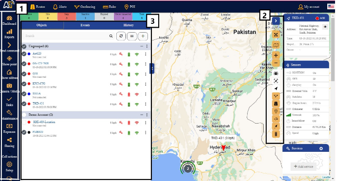
1) Menu.
2) Map control.
3) Navigation panel.
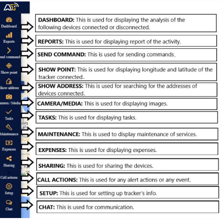
Menu
Map control

1) Full screen mode – hides all tools and shows only gps devices in the map
2) Change map – change map to streets, sattelite and more
3) Zoom – zoom in and out in the map
4) Objects tickbox – show or hide objects in the map
5) Geofences tickbox – show or hide geofences in the map
6) Routes tickbox – show or hide routes in the map
7) POI tickbox – show or hide POI in the map
8) Show names – show or hide objects names above icon in the map
9) Show tails – show or hide objects tails in the map.
Navigation panel

1) Objects tab – view and manage all devices.
2) Events tab – history of events and alerts/notifications can be viewed (overspeeding, geofence alert, low battery, etc.)
3) History tab – view detailed history for each gps device, graphs, data log.
4) Search – find devices by name or imei.
5) Add device – add new gps devices.
6) Groups – group name and number of devices in that group.
7) Groups expander – expand or collapse groups
8) Visibility checkbox – turns on or off objects visibility on map.
9) Object information – device name, date, time of last received location, online/idle/offline status.
10) Speed – shows current object speed.
11) Edit Object – change device icon, assign to a group, add and manage sensors, follow, accuracy settings and more.
Object Details panel
This panel allows you to see more information about object. It appears when you select your object. There are 2 options: show less(standard) and show more.
In show less popup you will see address, stop duration, sensors. In show more popup you will see additional information like services, protocol, etc.
